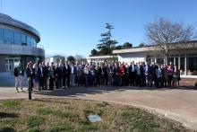
Sorry, you need to enable JavaScript to visit this website.
Skip to main content

un maps


4th Annual Conference: UN Maps Clinics “Enhancing UN Maps – from the field, for the field"

Submitted by michael.montani on
From 1 to 4 December 2025, UNGSC, in collaboration with OICT and the UN Geospatial Network, organized the UN Maps Clinic sessions “Enhancing UN Maps – from the field, for the field”, remotely. Participated by more than 350 UN personnel from 67 UN entities, the UN Maps Clinics provided a series of interactive and hands-on sessions that showcased updates of UN Maps features and applications, demonstrated outputs, and gathered feedback for future enhancement. It co-designed the roadmap of UN Maps to better plan the future steps to deliver coordinated support for UN’s daily operational activities.

UN Mappers in support of Türkiye and Syria - Mapping for Emergency Relief

Submitted by michael.montani on
The United Nations Global Service Centre (UNGSC) is at the forefront of adopting state-of-the-art geospatial technology to address UN operational needs. UN Maps was established in 2019 to support the mandates of UN peacekeeping missions and Agencies, Funds and Programmes based on a suite of geospatial solutions and by leveraging both UN-managed and open data sources.

Second UN Maps Conference, 6 – 10 March 2023, Valencia, Spain

Submitted by michael.montani on
The Second United Nations Maps Conference took place at the United Nations Information and Communications Technology facility (UNICTF) in Valencia, Spain, between 6 and 10 March 2023. It brought together around 45 entities and external partners to strengthen coordination, collaboration and the capacity of geospatial information to meet global challenges.