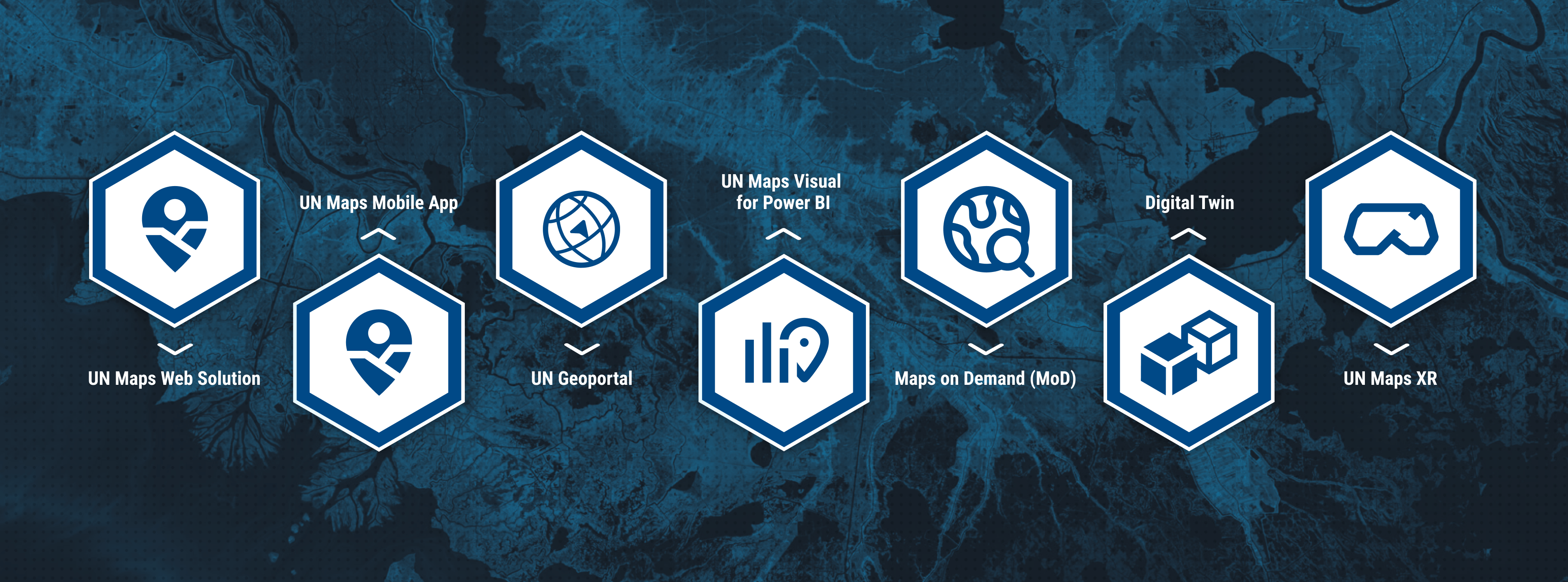
With a commitment to serving a diverse and expanding audience, UN Maps offers user-friendly tools tailored to meet various needs.
The UN Maps Application serves as a central hub, providing effortless access to the full spectrum of features within the UN Maps Ecosystem. Users can seamlessly navigate through our suite of tools and services, empowering them to explore, analyze, and make informed decisions with ease.
Meanwhile, the UN Geoportal opens doors to a world of geospatial data sourced from a variety of UN actors. Authorized users not only have access to this wealth of information but can also contribute by uploading and sharing their own data sources. This collaborative platform fosters knowledge exchange and enhances the collective understanding of global challenges.
Together, the UN Maps Application and UN Geoportal represent a commitment to accessibility, innovation, and collaboration in the field of geospatial technology, empowering users to navigate, analyze, and contribute to a more informed and connected world.
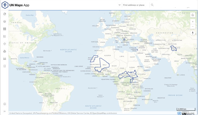
 UN Maps Web Application
The UN MAPS is a product developed and implemented by the Service for Geospatial, Information and Telecommunications Technologies SGITT for the Department of Field Support (DFS) and the Department of Peace Keeping Operations (DPKO).
The Application is designed to be accessible from any device equipped with an internet connection, and aims at improving the timeliness and quality of information used in strategic, operational and tactical decision-making and forecasting, presenting information in an intuitive format to the people who need it, and bringing heightened awareness to the field missions of the situations that will impact their operations and personnel.
Navigate confidently through urban landscapes or remote terrains with our detailed street-level maps, ensuring efficient travel to your destination. Gain valuable perspectives and analyze terrain with high-resolution imagery through UN Image map. Simplify logistics with our direction tool, finding optimal routes based on real-time factors. Quickly access locations and points of interest with intuitive search functionality. Support mission-critical operations with tools for planning, execution, and monitoring in real-time. Experience the world in 3D and gain insights into global dynamics with UN Maps Globe.
Click here to access the application.
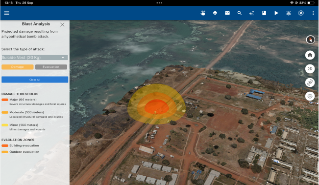
 UN Maps Mobile App
UN Maps Mobile is the most efficient and reliable way to access and utilize UN Maps services while on the field. Built with a map-centric approach, this application allows you to focus on specific areas of interest, maximizing the mobile capabilities of modern smartphones and tablets for seamless, on-the-go access.
By harnessing the power of your device’s sensors—such as GPS—you can track real-time locations, enhancing both situational awareness and decision-making in dynamic field operations. For those working in remote areas or regions with unreliable network coverage, UN Maps Mobile offers an offline mode, ensuring that vital maps and data remain accessible even without a live internet connection.
Beyond its basic mapping functionalities, the application provides a comprehensive suite of tools designed to enhance operational efficiency and safety. From real-time positioning and route planning to customized overlays that display key infrastructure, population centers, and mission-critical points of interest, UN Maps Mobile is designed to meet the unique demands of field personnel.
Incorporating the latest in mobile technology, UN Maps Mobile not only streamlines mission planning and execution but also enhances the overall safety and success of field operations.
Click here to access the application on IOS.
Click here to access the application on Android.
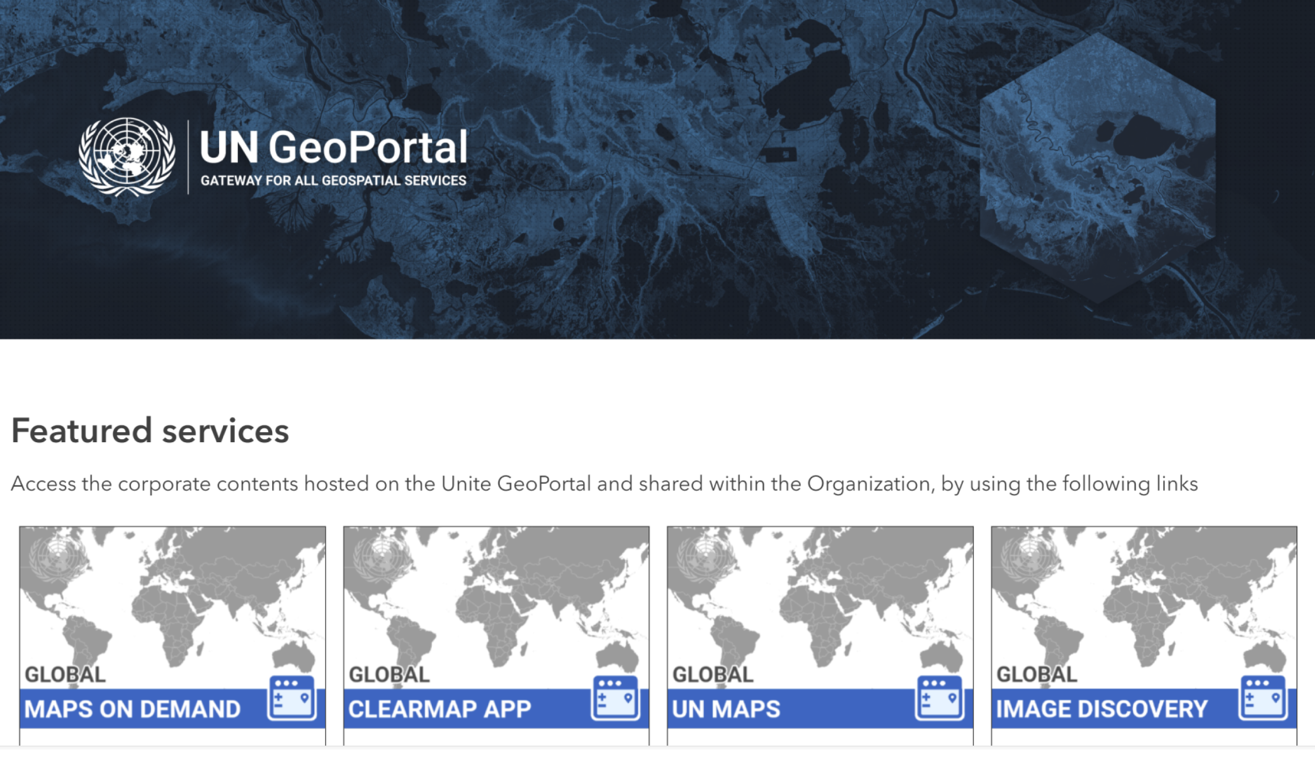
 UN Geoportal
The UN Geoportal is the gateway to a world of geospatial services provided by and for the United Nations and its partners.
SGITT provides to its customers secured access to online maps, products and other Solutions. This service is based on the UN GIS Cloud Infrastructure and allows the SGITT-GIS to disseminate any geospatial information or solution.
The UN GeoPortal is a content management and repository for GIS content and is designed as a platform to facilitate data sharing and dissemination and provide an efficient and secure access to GIS resources in the UN GIS Cloud.
This portal thus serves as a gateway to geospatial data hosted centrally and also includes quick web maps building, web mapping applications building and basic spatial analysis among other tasks.
The UN GeoPortal is based on the ESRI technology and uses the powerful UN GIS CLOUD infrastructure and capacities to provide its different components to the user. The service can host many types of solutions such as image service or web mapping services.
Click here to access the geoportal.
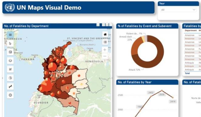
 UN Maps Visual For Power BI
The Power BI Service is your gateway to a world of business intelligence, bringing together data, analytics, and visualizations in one powerful, cloud-based platform.
Unlock insights from diverse data sources, create interactive reports, and collaborate seamlessly with your team—all from within a user-friendly interface. Whether you're analyzing business performance, tracking KPIs, or making data-driven decisions, Power BI Service empowers you to transform raw data into actionable insights, anytime, anywhere.
With real-time dashboards, customizable reports, and secure sharing, the Power BI Service makes it easier than ever to visualize and act on your data, driving smarter decisions across your organization.
CSDS published the first version of UN Maps for Power BI in May 2024. It's currently available for all the organization in the official list of enabled visuals. As a UN staff, you can use your UN account to login to the UN Geoportal and start adding layers and using its GIS enabled tools.
External users can also have access to the UN Geoportal, but they first have to be registered as guests.
 Maps on Demand Application (MoD)
Introducing Maps On Demand (MOD), a cutting-edge web application designed specifically for UN Peacekeeping Missions personnel. MOD empowers users to effortlessly download maps tailored to their areas of focus, streamlining operational planning and enhancing situational awareness.
Built with user experience in mind, MOD boasts an intuitive interface that ensures seamless navigation and accessibility for all users, including non-GIS personnel such as uniformed and military staff. With just a few clicks, users can access a variety of map types to suit their specific needs.
MOD offers topographic maps at a 50k scale, providing comprehensive coverage of UN Peacekeeping mission areas.
For urban environments, MOD delivers detailed 10k and 15k scale maps, showcasing building footprints and points of interest within cities.
Additionally, MOD offers site maps at unparalleled precision, available at scales of 1:2500 and 1:5000. These maps combine UN-sourced operational data with high-resolution satellite imagery, offering invaluable insights into UN field camps and other critical areas of interest.
Excitingly, MOD now features Road Books, a dynamic tool for navigating routes with ease. Users can input their departure and arrival points, generating a comprehensive PDF guide complete with essential information for each intersection.
Click here to access the application.

 Digital Twin
Digital Twin service aims to provide digital twins of urban, rural and mission camp infrastructure detailing different areas of interest (AOI) with geospatial data, 3D mapping technologies and advanced visualization techniques.
By leveraging drones, satellite imagery, LiDAR, planimetric and IoT data where appropriate the Client Solutions and Delivery Section has the expertise and resources to build digital twins that depict elements of the natural environment, facilities and assets that directly impact UN personnel and civilian populations in 3D. This type of data rich visualization provides relevant information to decision makers at the local, regional, national and international level.
Optimizing these visualizations by Levels of Detail (LOD) offers customers of this service the option for a streamlined approach that considers the format, size and necessary resources needed to support high quality and high functioning deliverables. The suggested Levels of Detail include:
LOD 1: Low complexity and low poly 3D schematic of the built environment on a terrain surface with stylized features.
LOD 2: Textured 3D Integrated Mesh with minimum clean-up.
LOD 3: Custom or Landmark 3D models added to a stylized schematic scene (LOD 1) or a textured mesh (LOD 2) by leveraging the UN 3D Asset Library in focus areas requiring heightened detail.
LOD 4: High complexity In-door/Out-door mapping leveraging additional techniques and technologies necessary for the reconstruction or design of indoor areas with architectural detail.

 UN Maps XR
Extended Reality (XR) services offer immersive and interactive solutions designed to support UN field missions and agencies. By leveraging XR and geospatial technologies, the service provides an innovative, collaborative platform that enhances understanding of complex environments through virtual experiences.
This service introduces a new approach to supporting peace operations, overcoming the challenges of distance and inaccessible locations. XR solutions offer valuable insights for managing problem-solving processes in field missions, empowering teams with tools for strategic planning, site selection, training, and security assessments—all in a safe, virtual setting.
The initiative includes three-dimensional interactive platforms that integrate digital twins and 3D UN Maps, maximizing their potential in field operations. These XR solutions are customizable to meet the specific needs of stakeholders, offering significant benefits such as improved safety and security, increased operational efficiency, optimized resource use, enhanced training, and better environmental awareness.