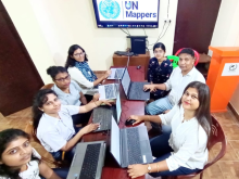
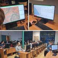
Sorry, you need to enable JavaScript to visit this website.
Skip to main content

training


A look back at the UN Maps training activities

Submitted by michael.montani on
The UN Maps project (initially called Unite Maps) was born in 2019, and the following year included training activities aimed at educating or empowering OSM communities to subsequently support the project in its mapping activities in support of partner peacekeeping missions. Over these four years, the UN Maps crowdsourcing team has organized nearly 40 workshops for about 1,200 people from a wide range of groups and communities, in five different languages: English, Spanish, French, Italian, and Portuguese.

Training with the National Advanced School of Public Works (ENSTP), Yaoundé, Cameroon

Submitted by michael.montani on
Located in the heart of Yaounde, Cameroon, is the ENSTP (National Advanced School of Public Works). This school provides training for engineers in different fields such as Civil Engineering, Environmental Engineering, Town Planning, Architecture and Land Surveys. The students here are introduced to concepts like topography, geodesy, projections, cartography, GIS and sustainable development. These make the student community in this school a target of high potential as concerns initiation to participative mapping.

Mapathon with Lodz university, Poland - November 30th, 2022

Submitted by michael.montani on
Lodz, Poland. On November 30, members of the OSM Polska Association, together with students of the Faculty of Geographical Sciences of the University of Lodz and supporters of the OpenStreetMap (OSM) project, for a total of 38 participants, met in the halls of the university to support the activities of UN Mappers and help them create maps of areas where United Nations humanitarian missions are carried out . Over the course of two and a half hours, the volunteers focused their efforts on mapping areas in a remote region of Somalia.

Training with universities and highschool in Valencia, Spain - November 10-17, 2022

Submitted by michael.montani on
Last month, the UN Mappers team carried out a series of activities in the Valencian Community, Spain, with the dual purpose of raising awareness of the UN Maps universe and training participants in the use of OpenStreetMap open data. Two prestigious universities, Universidad Jaime I (UJI) in Castellón and Universidad Politécnica de Valencia (UPV), and secondary school students from the Entrenaranjos International School, were involved.

Workshop on Capacity Building for Geospatial Information Actors in Bamako, Mali - September 12-16, 2022

Submitted by michael.montani on
Following exchanges between the Geospatial Information Section of the United Nations and the Geographical Institute of Mali within the activities of the United Nations Committee of Experts on Global Geospatial Information Management (UN-GGIM), in Africa (UN-GGIM Africa) and of the Second Administrative Level Boundaries (SALB) programme, the offices agreed to organize a workshop for the development and capacity building for actors on geospatial information in Mali.

Eurêka Géo Feat UN Mappers - Training on OSM mapping and tools

Submitted by michael.montani on
The training jointly organised by UN Mappers and Eurêka Géo from Cameroon took place from 26th March to 4th May 2021. This 12-hours online training aimed to strengthen the capabilities of the YouthMappers Chapters of Mbalmayo and Douala, Eurêka Géo students and the OpenStreetMap Cameroon community on OSM mapping using JOSM and iD Editor and data collection tools such as Kobo Collect; and to lay the foundations for a long and fruitful collaboration between Eurêka Géo and UN Mappers on future projects.